Before we hit the road today, we stopped for our usual coffee. Many of the sinks here are far too tiny for their purpose, if indeed their purpose is for washing normal-sized human hands.

It may have taken me nearly three weeks, but I’m more comfortable driving now. For one thing, I understand how the roads are laid out and what the symbols mean. A white triangle on the asphalt with its point facing you means you’re going the right way; don’t drive down a lane that has the flat side toward you. I’m starting to remember to look left when making a right turn, and in passing lanes to stay left unless I’m going fast, which I rarely am. Another reason for my relative peace of mind is that Syd is more used to having me behind the wheel so she pays less attention to what I’m doing. I don’t like being observed.
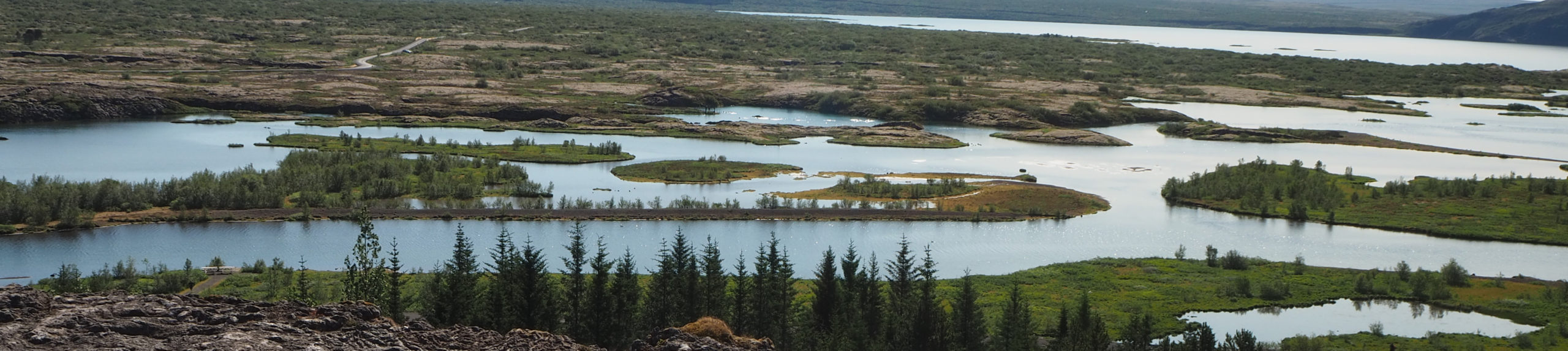
The trip up the Pacific coast from Oamaru to Ashburton takes about two hours, but it took us six. We took a rectangular inland route through Otematata and Omarama and Twizel to Lake Pukaki, Lake Tekapo, Fairlie and Geraldine. The objective was to get us up close to the east side of the Southern Alps and the peaks we couldn’t see when we drove down their west side last week.
Whenever we saw an interesting turnout or vista point, we took it. One was Takiroa in the Waitiki Valley.

A sign gave us a warm nau mai, haere mai (welcome) to the site of ancient MÄori rock paintings on a massive sandstone rock face with tafoni-type weathering (you know my source for the geology). Excited, we walked down the path to find the most of the work had been removed, ostensibly for a museum exhibit elsewhere, and the rest had been trashed by graffiti jerks. Here, the black drawings are ancient, nearly obliterated by recent carving.

It’s agricultural land here in the Canterbury, Otago and Mackenzie regions: sheep, deer, cattle and just a fistful of pigs. The alpine peaks in the background are unlike any I’ve seen before (not capture-able with my camera). You know how the snow on high mountains is sort of textured and soft-looking? Vast sweeps of this snow appeared as though they were glazed over with an unbroken sheet of ice, a vertical skating rink, shiny in the sun.

At Lake Pukaki in Mackenzie County, we walked down toward water’s edge for a look at the brilliant blue glacial-milk water.

Higher up the bank, the town had erected a statue of a collie, “without the help of which the grazing of this mountain country would be impossible.”

The provenance of the name Mackenzie County is interesting. According to a regional web site, it “is named after New Zealand’s most famous outlaw, James Mackenzie, a sheep rustler who, along with his sheep dog Friday, was accused of sheep stealing. He was finally captured in 1855, and after a series of escapes and increasing illness, he was released in 1856 and promptly disappeared forever.” I wonder why they chose him to name the region after. What do I have to do to get someone to name a region after me?

Tonight we’re staying in Ashburton at an actual motel for $115 a night, the Commodore Motor Lodge, since there are no BBH backpackers’ hostels nearby. That’s about double what we normally pay, but it’s better than driving into the night to the next place, or sleeping in our motorized tin box. It has a little kitchen where I reheated my leftover gnocci from two nights ago, and where I am now scarfing down potato chips, ginger digestive biscuits and wee mandarin oranges. I think this is the preferred diet for keeping a threatening cold at bay.
How’s Syd’s cold, BTW?
I thought your camera was super fancy-expensive; but it’s not good enough to capture the details of those ice-rink peaks, huh?! What a shame. You made them sound so delectable! (What’s the word I’m looking for?)
I’m really actually really offended by those grafitti jerks. Disgusting. Bunch of turkeys.